Papua New Guinea’s capital is expanding rapidly through informal settlements, but without accurate population data, urban planning remains a challenge.
It’s a simple question with profound implications: How many people live in Papua New Guinea? Despite five censuses since independence, we still don’t have a reliable answer.
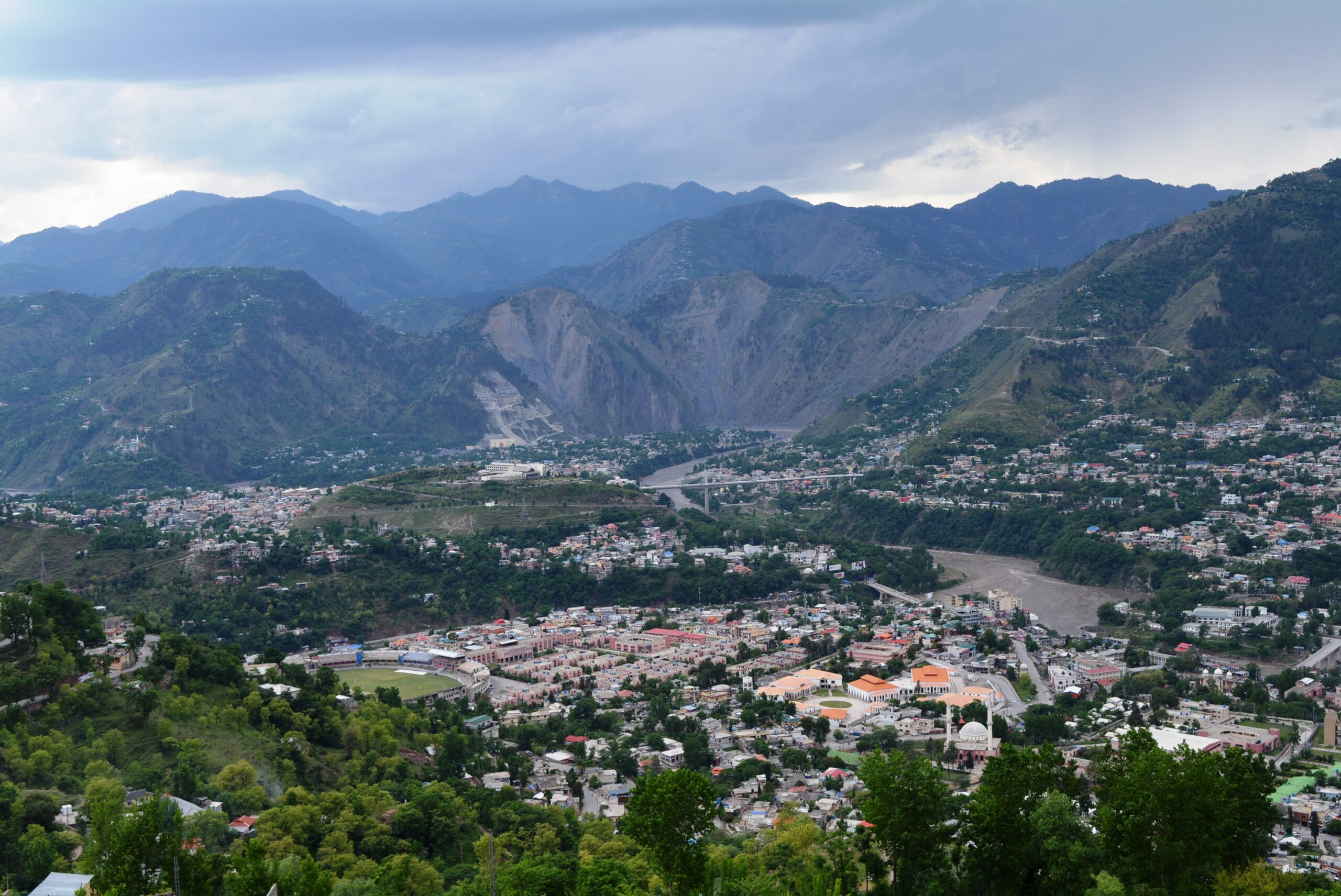
In Port Moresby, PNG’s capital, thousands migrate annually from rural villages seeking economic opportunities. With formal housing development lagging far behind demand, most newcomers settle in sprawling informal settlements that now house over half the city’s population.
My research offers a new methodology for estimating these settlement populations by combining satellite imagery analysis with ground-level interviews. Focusing on “8-Mile,” a well-established 2.5 square kilometre settlement northeast of Port Moresby’s center, I’ve tracked its growth over 18 years using freely available satellite imagery. The findings reveal a settlement that continues to expand despite repeated containment attempts—with significant implications for urban development policies.
The perennial data issue in PNG
Census-taking has long challenged PNG’s authorities. Of the five censuses conducted since independence, only those from 1980 and 2000 are considered generally accurate. Despite being widely regarded as failed, the 2011 census remains the primary dataset used by development agencies for program planning and implementation, simply because it’s the most recent macro-level dataset available with development metrics.
This 14-year-old data hardly reflects today’s reality. Port Moresby has transformed dramatically as the promise of jobs, education, and cash income has drawn thousands to the city, increasing the population from approximately 364,000 to over 510,000. Urban settlements have become permanent fixtures on the city’s periphery. Without knowing the true population size, government planners, development agencies, international experts, and businesses cannot make informed, data-driven decisions on critical issues.
Attempting to address this gap, the United Nations Population Fund (UNFPA) estimated PNG’s population in 2021 using various methods, including extrapolating population data from structures visible in satellite imagery—a technique previously successful in Africa. The technique’s use in rural PNG, however, has been criticised. PNG census officials argue that outside densely populated urban centres, house-like structures cannot be reliably proxied for households. Initial findings employing this method suggested PNG’s population was over 50% higher than government estimates (17 million versus 11 million). If accurate, this would have significantly lowered PNG’s per capita development metrics. The government, elected on promises of national economic development, suppressed the report.
Seven months later, a revised UNFPA estimate was published with government support, showing a moderate nationwide population increase. Crucially, it omitted data on health, education, or economic activity—information typically gathered during a full census and vital for development planning.
The government’s 2024 census attempt appears to have fallen short as well. Logistical and administrative constraints reduced the standard comprehensive questionnaire to just six basic identification questions. While official declarations are pending, it is highly likely the 2024 census has failed.
As of today, high-quality, reliable population data remains scarce in PNG.
Delivering services to an invisible population
This data vacuum severely complicates development planning. Port Moresby now suffers frequent blackouts and brownouts due to aging electrical infrastructure and proliferating illegal connections. Load shedding hasn’t resolved the issue, making “PNG Power has no power” a common refrain among residents.
Water infrastructure faces similar challenges. The Mt Erima treatment plant, built in 1965 by the Australian colonial administration, desperately needs upgrading to meet growing demand. As of 2020, only 62% of the plant’s daily water output was authorised, while 11% was tapped illegally and 27% lost through leakage.
Media narratives frequently blame settlement dwellers for these utility shortages, characterising these areas as centres of criminality where illegal connections and theft are commonplace. The reality is more nuanced: settlements have simply been excluded from formal systems.
8-Mile, the focus of my study, was established as a major settlement in the 1980s by people seeking to recreate village life after moving to the city. The vast majority were highlanders. They felt dissatisfied with urban living and isolated from the familiarity of extended village social networks. They relocated to the burgeoning settlement collectively from all over Port Moresby. Together, they negotiated customary arrangements with traditional landowners, built their own houses, and established their own utility connections. Many resumed gardening as they had in their native Morobe and Simbu provinces, supplying vegetables to the city’s informal economy. These settlers expected no government support and received none; their self-reliance became known as the “self-help” movement.
Settlements have since expanded and multiplied, serving as landing pads for incoming rural-urban migrants. They still largely lack formal services despite housing over half of Port Moresby’s population. Until now, there has not been a practical, clearly articulated method for counting settlers and measuring urban morphology changes in settlements over time.
New insights through satellite mapping
My technique involves identifying individual residential structures from high-resolution satellite imagery and tracking their appearance and disappearance over time. By combining this visual data with information about typical household sizes in informal settlements, I’ve developed reliable population estimates that can be compared year-to-year.
For 8-Mile, this revealed a minimum population of 25,000 as of January 2024. This has more than doubled since 2006 and growth is continuing.

This growth persists despite infrastructure developments significantly impacting the settlement, such as the construction of the “8-Mile highway” and extensive commercial rezoning along its periphery. While these developments have caused residence demolitions, they’ve also led to increased structural density within the settlement—strongly suggesting that evictees choose to move deeper into the settlement rather than leave entirely.
For government planners, this demonstrates a crucial lesson: settlements cannot be managed through demolition alone.
The way forward
To address Port Moresby’s settlements, administrators must confront their root causes: poor integration—culturally, economically, and geospatially—of PNG’s rural-urban migrants. Connecting settlements—and therefore the majority of the city’s population—to basic services and the formal economy is essential for dismantling this exclusion. But this process requires access to good data.
To address Port Moresby’s settlements, administrators must confront their root causes: poor integration—culturally, economically, and geospatially—of rural migrants drawn by big city opportunities and urbanites squeezed out of formal housing. This has created a dual city where marginalised settlements house the majority of residents yet remain disconnected from formal systems. De-marginalisation, by connecting settlements to basic services and the formal economy, is essential for genuine urban development. However, this necessary transformation cannot proceed effectively without access to good data.
High-quality, reliable population information is vital for planning resource allocation and service delivery across Port Moresby to maximise the benefits of development programs run by governments, international agencies, and businesses.
By combining satellite imagery analysis with on-the-ground research, we can begin to fill this critical data gap and develop more effective, inclusive urban policies that recognise the reality of Port Moresby’s rapid urban growth.
Bradley Dare has completed a Masters degree in Pacific Development and continues his Pacific-focused research in association with the Australian National University. This article is based on a larger comprehensive study of 8-Mile’s urban morphology currently under review for publication. He can be reached at bradley.dare@anu.edu.au.
This article is published under a Creative Commons License and may be republished with attribution.